![](/images/other/stat-length.png)
![Tocht Andere activiteiten Val de Bagnes - Brunet - Avouillons - Panossière - La Maye - Brunet - Photo](https://media.geolcdn.com/t/1900/400/ext.pjpeg?maxdim=2&url=https%3A%2F%2Fstatic1.geolcdn.com%2Fsiteimages%2Fupload%2Ffiles%2F1545311037marcheuse_200dpi.jpg)
Brunet - Avouillons - Panossière - La Maye - Brunet
fcrittin
Gebruiker
![Lengte](/images/other/stat-length.png)
![Max. hoogte](https://static1.geolcdn.com/siteimages/upload/files/1508320355ic_sort_altitude_max_24dp.png)
![Positief hoogteverschil](https://static1.geolcdn.com/siteimages/upload/files/1508320355ic_sort_den_pos_24dp.png)
![Km-Effort](/images/other/stat-length.png)
![Min. hoogte](https://static1.geolcdn.com/siteimages/upload/files/1508320355ic_sort_altitude_min_24dp.png)
![Negatief hoogteverschil](https://static1.geolcdn.com/siteimages/upload/files/1508320355ic_sort_den_neg_24dp.png)
![Boucle](https://static1.geolcdn.com/siteimages/upload/files/16400158638029165_repeat_loop_refresh_sync_direction_icon.png)
![Andere activiteiten](https://static1.geolcdn.com/sitytour/trail-icons/900.png)
--
Moeilijkheid : Onbekend
![Scan deze QR-code om de tocht te openen in de SityTrail-applicatie](https://capi.geolives.com/qq0zvz2zws4bq2lad0pu/sitytour/trails/18177/qr.png?size=200)
Gratisgps-wandelapplicatie
Over ons
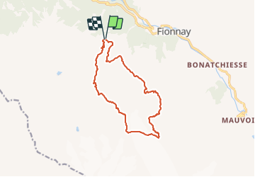
Tocht Andere activiteiten van 14,1 km beschikbaar op Valais/Wallis, Entremont, Val de Bagnes. Deze tocht wordt voorgesteld door fcrittin.
Beschrijving
Loutze - Cabane Rambert - Col et Lac de la Forclaz - Loutze.
De la buvette de Loutze suivre le petit sentier dans la forêt pour rejoindre la route d''alpage menant aux écuries de Chamosentze. Aux écurie monter la petite pente pour arriver sur le plat de Chanrion puis la seconde en suivant le fond de vallée des Outannes et bifurquer sur la gauche à flanc de côteau. Remonter la dernière petite pente pour rejoindre le sentier arrivant d''Ovronnaz puis arrivée à la cabane. De là prendre derrière la cabane un petit sentier pour redescendre sur le pierrier amenant au col de la Forclaz. Au col, contourner le pierrier ou le névé éventuel par la gauche et rejoindre le barrage qu''on traverse avant d''attaquer la pente raide des Palantzons et retrouver le chemin de la montée au sommet du plat de Chanrion.
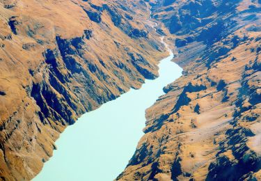
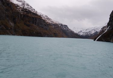
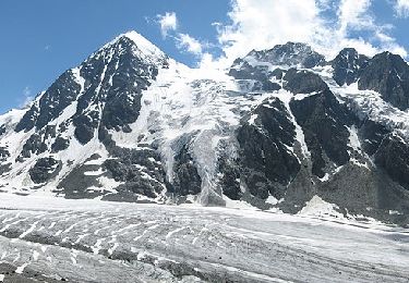
Faune : marmottes - chamois - bouquetins - lagopèdes - aigle - gypaête
Plaatsbepaling
Opmerkingen
Wandeltochten in de omgeving
![Tocht Te voet Val de Bagnes - Pazagnou-Col des Otanes - Photo](https://media.geolcdn.com/t/375/260/dev_fb1da9d9-79d4-4584-a7b0-30a04b7a4ee0.jpeg&format=jpg&maxdim=2)
![Te voet Te voet](https://static1.geolcdn.com/sitytour/trail-icons/100.png)
Te voet
![](/images/other/stat-length.png)
![](https://static1.geolcdn.com/siteimages/upload/files/16400158638029165_repeat_loop_refresh_sync_direction_icon.png)
![Tocht Te voet Val de Bagnes - Fionnay-Bonatchiesse - Photo](https://media.geolcdn.com/t/375/260/722b9f42-8e6c-40c8-97d5-9a76a6e7f852.jpeg&format=jpg&maxdim=2)
![Te voet Te voet](https://static1.geolcdn.com/sitytour/trail-icons/100.png)
Te voet
![](/images/other/stat-length.png)
![](https://static1.geolcdn.com/siteimages/upload/files/16400158638029165_repeat_loop_refresh_sync_direction_icon.png)
![Tocht Te voet Val de Bagnes - Louvie-Fionnay - Photo](https://media.geolcdn.com/t/375/260/5fd2d0df-c707-4ac6-b9ec-327205fb196f.jpeg&format=jpg&maxdim=2)
![Te voet Te voet](https://static1.geolcdn.com/sitytour/trail-icons/100.png)
Te voet
![](/images/other/stat-length.png)
![](https://static1.geolcdn.com/siteimages/upload/files/16400158638029165_repeat_loop_refresh_sync_direction_icon.png)
![Tocht Te voet Val de Bagnes - Col Termin-Louvie - Photo](https://media.geolcdn.com/t/375/260/5fd2d0df-c707-4ac6-b9ec-327205fb196f.jpeg&format=jpg&maxdim=2)
![Te voet Te voet](https://static1.geolcdn.com/sitytour/trail-icons/100.png)
Te voet
![](/images/other/stat-length.png)
![](https://static1.geolcdn.com/siteimages/upload/files/16400158638029165_repeat_loop_refresh_sync_direction_icon.png)
![Tocht Stappen Val de Bagnes - Mauvoisin Bonatchiesse - Photo](https://media.geolcdn.com/t/375/260/d8ed992b-e50a-48df-a959-9a284479d634.jpg&format=jpg&maxdim=2)
![Stappen Stappen](https://static1.geolcdn.com/sitytour/trail-icons/101.png)
Stappen
![](/images/other/stat-length.png)
![](https://static1.geolcdn.com/siteimages/upload/files/16400158638029165_repeat_loop_refresh_sync_direction_icon.png)
![Tocht Te voet Val de Bagnes - Promenade de la Dranse - Photo](https://media.geolcdn.com/t/375/260/086adfed-46f4-4991-8417-75cd394f8ae1.jpeg&format=jpg&maxdim=2)
![Te voet Te voet](https://static1.geolcdn.com/sitytour/trail-icons/100.png)
Te voet
![](/images/other/stat-length.png)
![](https://static1.geolcdn.com/siteimages/upload/files/16400158638029165_repeat_loop_refresh_sync_direction_icon.png)
![Tocht Te voet Val de Bagnes - Chemins pédestres, région Bagnes - Photo](https://media.geolcdn.com/t/375/260/8db834a7-d9d6-41f8-95ac-2756844d7a1f.jpeg&format=jpg&maxdim=2)
![Te voet Te voet](https://static1.geolcdn.com/sitytour/trail-icons/100.png)
Te voet
![](/images/other/stat-length.png)
![](https://static1.geolcdn.com/siteimages/upload/files/16400158638029165_repeat_loop_refresh_sync_direction_icon.png)
![Tocht Te voet Val de Bagnes - Bruson - Moay - Photo](https://media.geolcdn.com/t/375/260/086adfed-46f4-4991-8417-75cd394f8ae1.jpeg&format=jpg&maxdim=2)
![Te voet Te voet](https://static1.geolcdn.com/sitytour/trail-icons/100.png)
Te voet
![](/images/other/stat-length.png)
![](https://static1.geolcdn.com/siteimages/upload/files/16400158638029165_repeat_loop_refresh_sync_direction_icon.png)
![Tocht Te voet Val de Bagnes - Panossière-La Maye - Photo](https://media.geolcdn.com/t/375/260/ae1e4313-39ab-4fa3-a2a7-bd7df4ca790e.jpeg&format=jpg&maxdim=2)
![Te voet Te voet](https://static1.geolcdn.com/sitytour/trail-icons/100.png)
Te voet
![](/images/other/stat-length.png)
![](https://static1.geolcdn.com/siteimages/upload/files/16400158638029165_repeat_loop_refresh_sync_direction_icon.png)